Maps of the Best Bicycle and Ski trails on the Kenai Peninsula
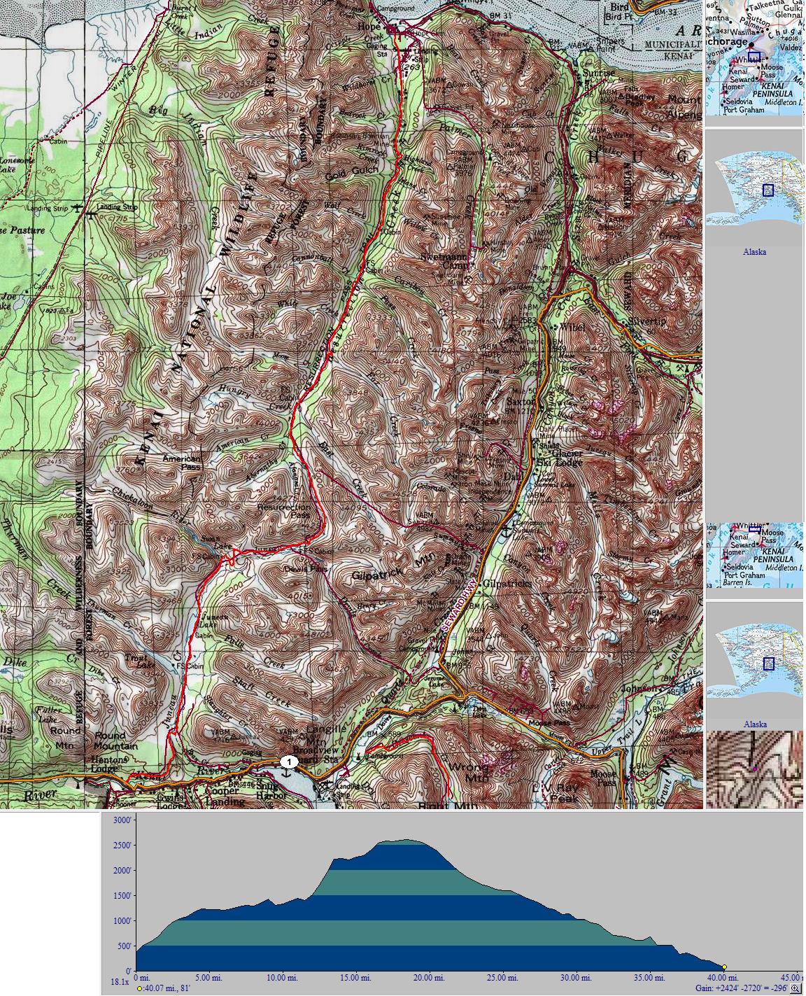
Resurrection Pass
Intermediate/Difficult
Running between Hope and Cooper Landing, Resurrection Pass is the premier mountain bike trail on the Kenai Peninsula. Shared with Hikers and Equestrians, Resurrection Pass winds 38.6 miles through an alpine pass once used by turn of the century miners searching for gold. The difficulty of the trail depends on distance and destination. Expect technical sections, as well as flowing trail. Trail conditions vary based on season and recent rainfall. Resurrection does not get overgrown late into the season, but does suffer from extensive use and rainfall in the fall months. The trail is open to snowmachines every other year, and non motorized use year round. During snowmachine years the trail is excellent for fatbike use.
Make it a multi-day trip: Reservable Forest Service Cabins dot the route, and primitive camping is available all along the route. Be sure to bring a way to filter water as there is no potable water along the route. Don’t forget to stop by the Seaview Cafe in Hope to reward yourself for a trail well biked.
To the trail: Access Resurrection Pass from mile 53.1 on the Sterling Highway or mile 4 on Resurrection Road outside Hope. Traveling from Soldotna the trailhead will be on your left right before crossing the Kenai River. Looks for signs indicating trailhead Parking. The Kenai Pensinula is home to dangerous wildlife and weather, always be bear aware and prepared for changing weather conditions.
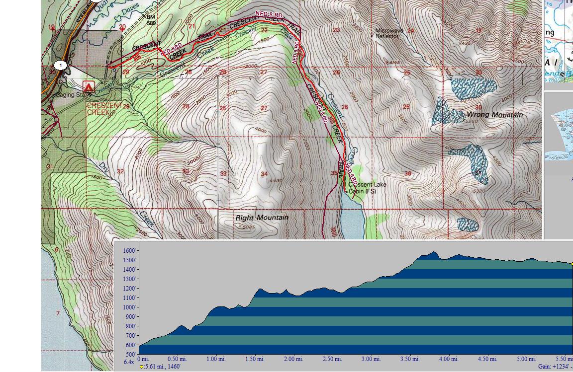
Crescent Lake
Intermediate
Mark’s favorite ride, Crescent Lake is a 6.4 mile in and out trail traversing along Crescent Creek before ascending into an alpine valley ending at Crescent Lake Cabin. At 12.8 miles round trip, Crescent is easily ridden in one day. The trail has several convenient landmarks to turn around at if you’re looking for a shorter day trip. Trail conditions are generally good, expect several muddy sections in the upper half if there has been recent precipitation. The trail oscillates between technical root and shale sections, and singletrack flowing along the creek. Be sure to stop at the creek and lake to wash off any Pushki you may have ridden through; the trail becomes more overgrown later in the season, but remains rideable throughout the summer
Make it a multi-day trip: Make a reservation to stay at the Crescent Lake Cabin, or try the primitive trail between Crescent and Carter Lakes. While not recommended for biking, if you can find your way through, the trail ends with the steep, but exciting descent of the Carter Lake Trail.
To the trail: From Soldotna, head to mile 44.9 of the Sterling highway and turn right on Quartz Creek Road. Follow the road as it heads 3.4 miles back along Kenai Lake. The trailhead is on the left at the end of the maintained road.
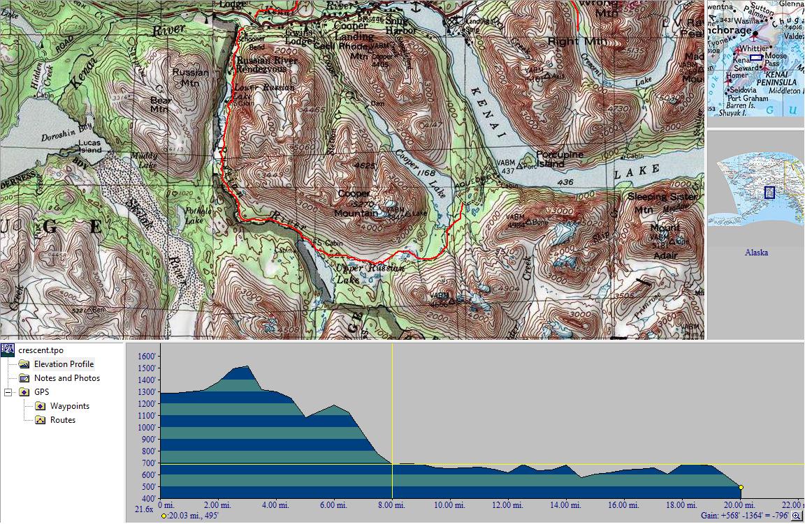
Russian Lakes Trail
Easy/Intermediate
A trail with split personalities, Russian Lakes Trail contains both rocky technical singletrack and wheelchair accessible sections, making it suited for all types of riders. The trail runs along the Russian River past the Lower and Upper Russian Lakes. Riders planning on riding through or looking for exciting singletrack start at the Cooper Lake Trailhead. Riders looking to enjoy a leisurely ride to the falls or the 2.6 miles to Lower Russian Lake start at the Russian River Campground trailhead. Be extra vigilant, though a popular trail, the Russian River area is frequented by many bears looking to feast on the many salmon that make the Russian River one of the best sportfishing locations in the world.
Make it a multi-day trip: Camp along the way, or use it as a launching pad for an extended version of Resurrection Pass. Russian Lakes Trail ends half a mile from the southern Resurrection Pass Trailhead, and connects to the primitive Resurrection River Trail (not recommended for bicycles or inexperienced hikers) which runs to Seward. There are three USFS cabins along the trail, and campgrounds at both trailheads.
To the trail: Riders typically start at the Cooper Lake trailhead. Head to Sterling Highway mile 47.9 and turn onto Snug Harbor Road. Follow the road 11 miles in and you will find the trailhead on your right. The Russian River Trailhead is located at mile 52.6 of the Sterling Highway. The parking lot is in the campground, so expect to pay a fee to park, or park by the South Resurrection trailhead and ride the half mile back to the trailhead.
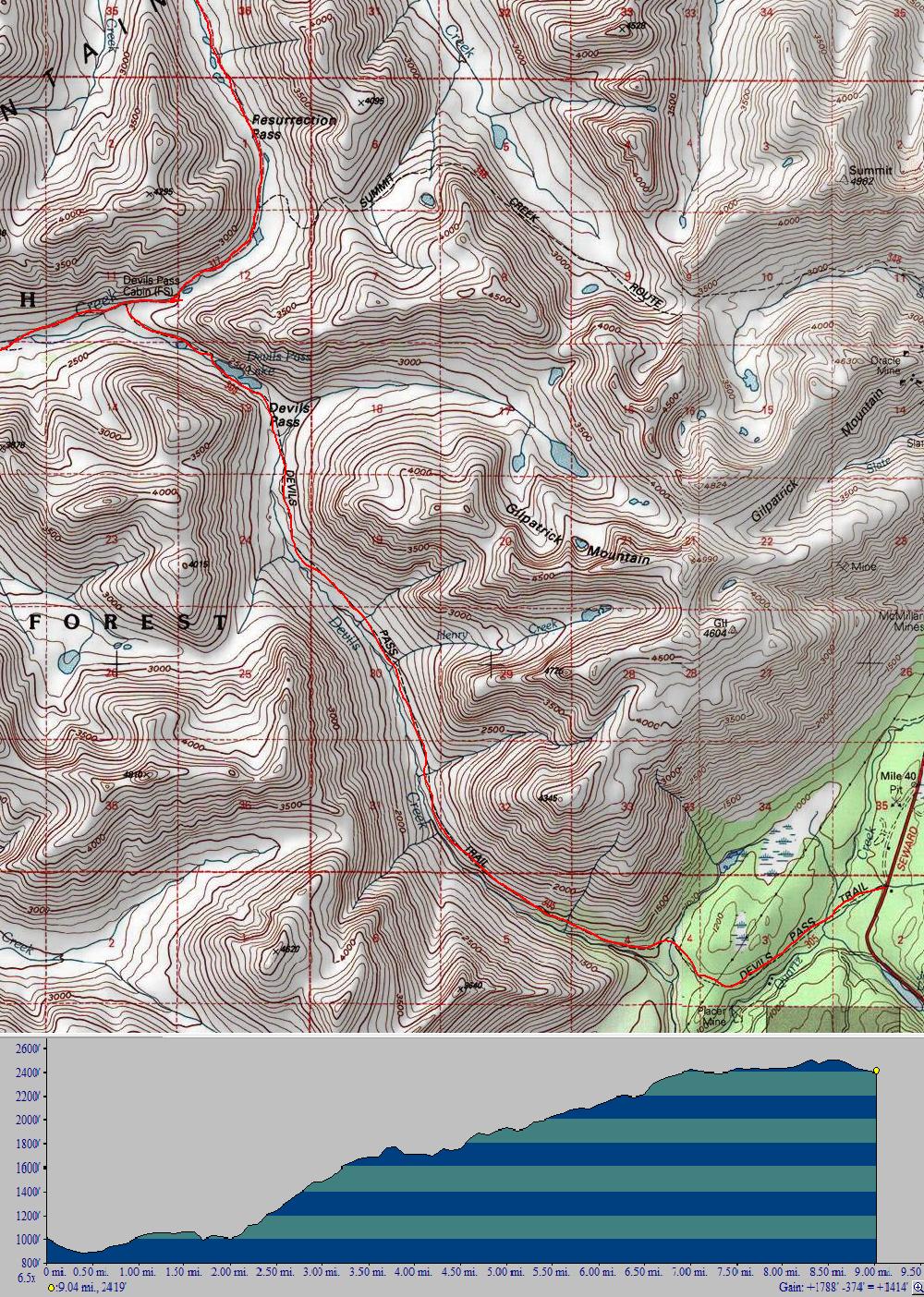
Devil’s Pass Trail
Intermediate
Alpine meadows, creek crossings, and a technical rock garden define this arduous trail. More fire road than singletrack, Devil’s Pass is a challenging climb along Devil’s Creek up to a junction with Resurrection Pass. Usually ridden as an out and back, this 10 mile trail can be used as an access point to Resurrection Pass (31.6 mi to the Hope trailhead, 27.2 to the Kenai River trailhead). Devil’s Pass is a shared use trail, so watch out for hikers, equestrians, and the occasional llama. The trail frequently cross the creek, so watch out for washouts and the surprisingly technical creek crossings. Well maintained, this trail remains passable throughout the season whenever dry, and experiences no overgrowth.
Make it a multi-day trip: Connect with the Resurrection Pass Trail for a new approach to an old classic or ride up to the Devil’s Pass Cabin for an extended out and back. The alpine valley and lake at the end of the trail make for a relaxing camping experience. Be sure to bring hiking shoes as the mountains invite you to scramble up them and enjoy a birds eye view of the peninsula.
To the trail: From Soldotna head left at the junction with the Seward Highway. The trailhead is at mile 39.5 Seward Highway shortly after the junction. A brown and Forest Service sign indicates the parking lot on the left. There are vault toilets at the trailhead.
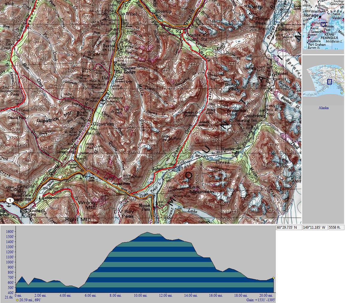
Johnson Pass
Intermediate
This 21 mile trail is one of the most elusive trails on the Peninsula. Winding along part of the original Iditarod route, Johnson Pass quickly transitions from snowed over to overgrown with cows parsnip (a uvf activated poisonous plant also known as pushki or wild celery). Look out for remnants of past times when the pass was the primary land route between Seward and the outside world, abandoned cabins and historical remnants remain in the area. Johnson Pass is usually ridden from the Anchorage side (north), but riders freely travel in both directions. Commonly called the hardest 21 miles of mountainbiking in Alaska, the trail is technically intermediate, but involves a lot of elevation gain. It is a shared trail so expect to see hikers and horses and yield accordingly.
Make it a multi-day trip: Johnson Pass has no USFS cabins, but dispersed camping is available. Be sure to practice bear safety, and be especially careful to remove your food from your campsite, as bear proof boxes are not prevalent.
To the trail: The Anchorage trailhead sits at mile 63.8 of the Seward Highway. Look for the signs indicating Johnson Pass, it will be on your right if you’re traveling from Soldotna. The Seward trailhead is at mile 32.5 of the Seward Highway.
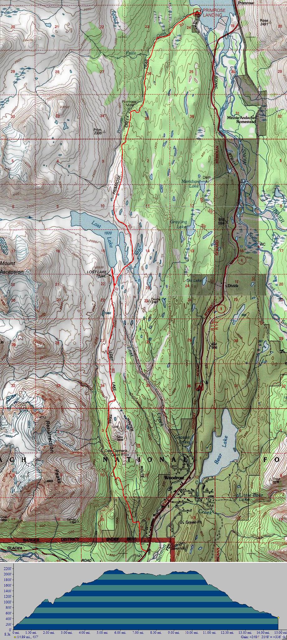
Lost Lake
Difficult
Lost lake is a difficult, technical trail from just outside of Seward, Alaska climbing quickly to above treeline where you are treated to stunning views of downtown Seward and Resurrection Bay. Many riders connect a climb up Lost Lake to a descent down Primrose Trail. While Lost Lake trail is rocky, technical and full of switchbacks, Primrose is very rooty with many natural step downs and technical, difficult sections. When riding Lost to Primrose (the reverse is not recommended) you will have to shuttle between the two trailheads. Some ride but the highways is busy in the summer and two vehicles is recommended.
Make it a multi-day trip: The Dale Clemens cabin is open year round and is one of the best cabins to stay in on the peninsula. In the winter it features propane heat, and immediate access to great skiing, snowmachining, or alpine adventure.
To the trail: The Lost Lake Trailhead is at Mile 5 of the Seward Highway. You will initially drive through a subdivision to get to the trailhead, but it is well marked. The Primrose trailhead can be found at Mile 17 of the Seward Highway. Follow the signs to the Primrose campground and park in front of the lake.
Local Rides
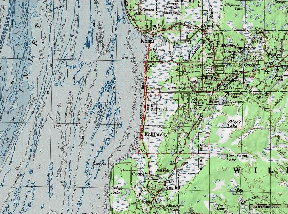
Kenai-to-Kasilof Beach Ride
Easy
Perfect for fat biking, this 10 mile beach ride winds from the mouth of the Kenai River to the Mouth of Kasilof River. Wind your way along the shoreline of the beautiful Cook Inlet. The flat open beaches of Alaska offer majestic views of mountains and a quiet sanctuary to ride your bike away from all the traffic of the roads. The start of this route is easily accessible from Kenai or Soldotna, and riders can ride this route one way or as a there and back ride. Be sure to watch out for set-net lines running along the beach, as this is an active fishing area during the summer months.
Make it a multi-day trip: Plan beach trip from the mouth of the Kenai to the end of the Homer Spit. Be sure to route around the multiple river crossings on the beach by cutting into the highway that runs parallel to the beach or by bringing a pack raft (not recommended) Bring all the food and water you need, there aren’t many stores along the way. Be sure to bring warm clothing, Alaska beaches are often cold and windy, even during the height of summer.
To the trail: Drive 8.4 miles out Kalifornsky Beach Road to Cannery Road. Turn right and continue along Cannery Rd. until you see signs for beach parking, which will be on your left. There is plenty of parking, but no toilets.
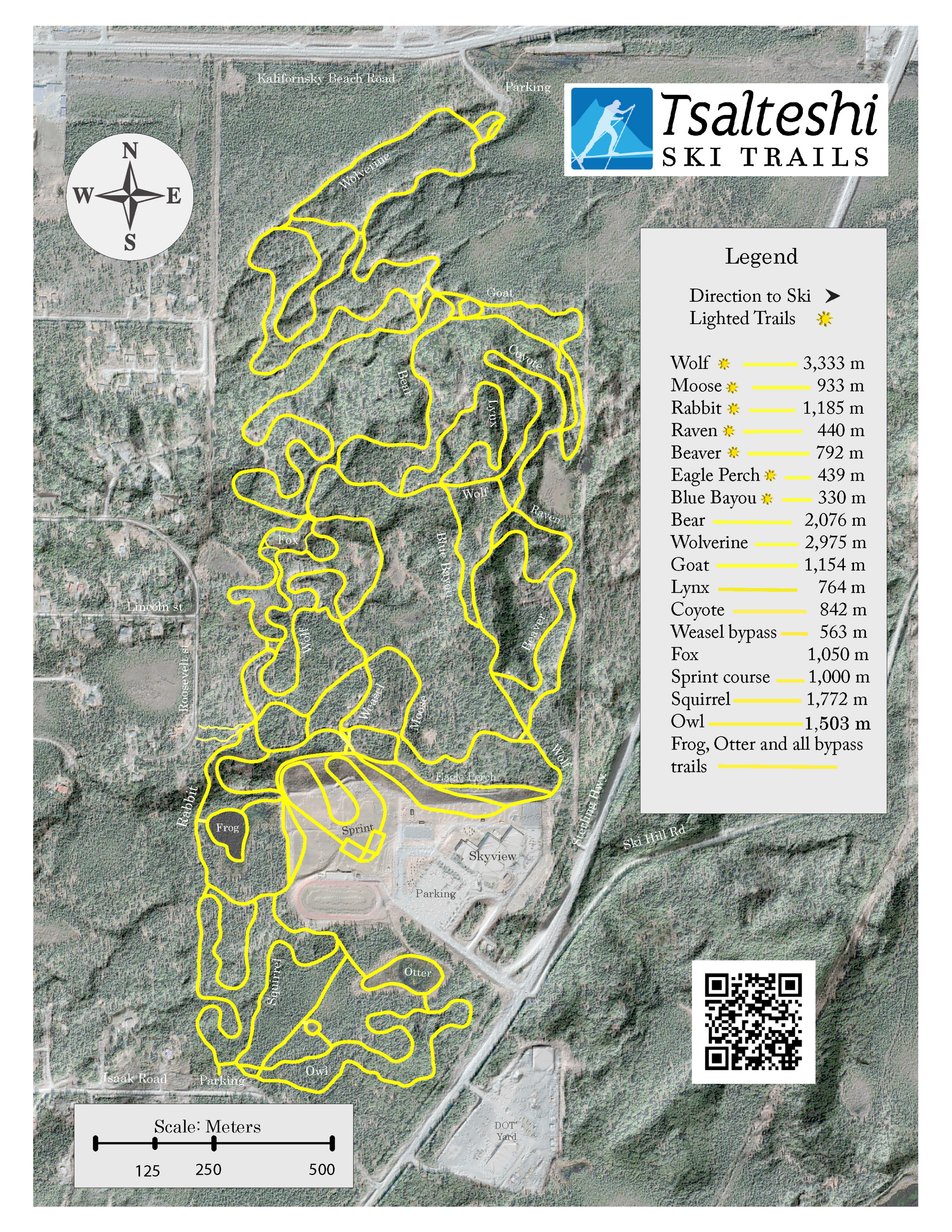
Tsalteshi Trail System
Choose Your Own Adventure
Located just south of Soldotna with entrances in the Skyview parking lot and across from the Soldotna Sports Center, Tsalteshi is the Kenai Peninsula’s premier skiing, running and biking trails. Tsalteshi, a Dena’ina word meaning Black Stone Axe Ridge begain construction in 1990; there are currently over 15 miles of fully constructed trails. Dedicated to skiing in the winter, and open to hiking, biking, leashed pets and running in the summer, these world class trails are provided free of charge for the peninsula’s residents. During the winter the trails are groomed and some are lit until 9 pm. The Tsalteshi Trails Association funds the maintenance and construction of new trails through land use grants and membership dues. You can join or donate here and help keep the trails open for all to enjoy.
Starting in 2013 the TTA, in co-operation with Beemun’s and zealous volunteers, began building a dedicated singletrack system that winds through the north side of Tsalteshi. This ever expanding trail network, accessed from the parking lot across from the sports center, is the first of its kind of the Kenai Peninsula. If you would like to help, a volunteer sign up list can be found upstairs in Beemun’s, in the Bike and Ski Loft.
Make it a multi-day trip: What are you crazy? You can’t sleep out here, go home and come back tomorrow.
To the trail: Parking lot across from the Soldotna Sports Center and at Skyview Middle School.


